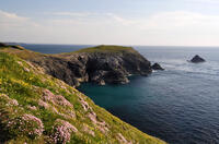
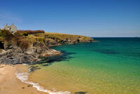
Boobys Bay

Booby's Bay gets it's name from the seabird related to a gannet (the name itself is based on the Spanish word for "stupid" as the birds were easy to catch and eat) which are not native to the UK so it's probably actually gannets that gave rise to the name.
At high tide, the beach is little more than rock platforms, but as the tide goes out, a sandy beach is revealed. The wreck of the SS Carl is buried in the sand and sometimes exposed after winter storms.
- Tide times
- Beach info
- Map
- Dogs: allowed all year
Walks visiting Boobys Bay
-
2 miles/3.2 km - Easy
Trevose Head (short version)

Trevose Head (short version)
2 miles/3.2 km - Easy
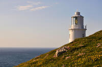
A circular walk around the rugged coastline of Trevose Head via the iconic lighthouse and golden sandy beach at Mother Ivey's Bay, with spectacular wildflowers in spring and summer and thundering waves in winter that sometimes expose the shipwreck at Booby's Bay.
-
6.1 miles/9.7 km - Easy-moderate
Trevose Head

Trevose Head
6.1 miles/9.7 km - Easy-moderate
A circular walk around the rugged coastline of Trevose Head via the iconic lighthouse and golden sandy bays of Constantine, Booby's, Mother Ivey's and Harlyn, with spectacular wildflowers in spring and summer.
-
6.8 miles/10.9 km - Easy-moderate
Seven Bays (via bus)

Seven Bays (via bus)
6.8 miles/10.9 km - Easy-moderate
A one-way coastal walk, made circular via an initial bus journey, along the Seven Bays coast and around Trevose Head past the lighthouse.
Download the iWalk Cornwall app and use the QR scanner within the app to find out more about any of the walks above.

