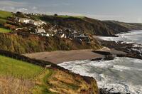
Downderry beach

Downderry beach is mostly grey sand at high tide but as the tide goes out, rock platforms with rockpools are exposed in many places with sandy lagoons between some areas of rocks.
At low tide, it's possible to walk a mile west (right if facing the sea) along the beach to Seaton. As the tide rises, boulders below the sea wall separate the two.
Also only at the lowest point of the tide (for around an hour, depending on spring/neap tides and size of waves), the eastern (left) end of Downderry beach is connected to another half a mile of beach that ends in Shag Rock. Between the two, there is an area backed with cliffs that is covered when the tide comes in and a ridge of rock that protrudes into the sea at the end of the main Downderry beach so extra care must be taken not to be cut off by the tide if venturing this way.
- Tide times
- Beach info
- Map
- Dogs: allowed all year
Circular walks visiting Downderry beach
-
6.7 miles/10.8 km - Moderate-strenuous
Portwrinkle to Downderry

Portwrinkle to Downderry
6.7 miles/10.8 km - Moderate-strenuous
A circular walk around Whitsand Bay to Downderry from Portwrinkle, where the ghost of Silas Finn is said to haunt the cliffs.
Download the iWalk Cornwall app and use the QR scanner within the app to find out more about any of the walks above.

