Hallane beach

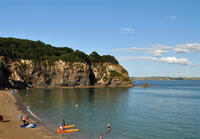
Hallane is a south-facing shingle beach with submerged rocks a short way offshore which surface as the tide goes out, and at low tide, a rocky platform is exposed along the shoreline. It is very sheltered which makes it suitable for swimming, and the offshore rocks provide a suitable spot for a rest and warm-up although care must be taken of the sharp barnacles. On the right-hand side of the beach, a waterfall cascades over a natural arch. At low tide, it is possible to walk around the arch to get behind the waterfall; slippery algae grows on the rocks beneath the waterfall so climbing through it is not recommended.
- Tide times
- Map
- Dogs: allowed all year
Walks visiting Hallane beach
-
7.6 miles/12.3 km - Moderate-strenuous
Mevagissey to Charlestown (via bus)

Mevagissey to Charlestown (via bus)
7.6 miles/12.3 km - Moderate-strenuous
A one-way coastal walk, made circular via an initial bus journey, from the fishing port of Mevagissey to Charlestown - one of the best-preserved Georgian ports in the world and an engineering masterpiece which included a seven-mile-long leat.
-
5 miles/9 km - Strenuous
Porthpean to Black Head

Porthpean to Black Head
5 miles/9 km - Strenuous
A circular walk from the sandy beach at Porthpean, past the brilliant white shingle beaches at Silvermine to the Iron Age fort on Black Head, returning via the site of an Iron Age metal works with spectacular views over St Austell Bay.
-
6.6 miles/10.6 km - Strenuous
Pentewan Valley and Black Head

Pentewan Valley and Black Head
6.6 miles/10.6 km - Strenuous
A circular walk from the lost port of Pentewan along the coast to the remains of the Iron Age fort overlooking St Austell Bay on Black Head, returning via the nature reserve that was once the King's wood and the trackbed of the horse-drawn tramway used for china clay and Sunday School outings.
Download the iWalk Cornwall app and use the QR scanner within the app to find out more about any of the walks above.

