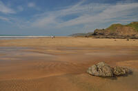
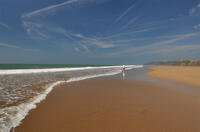
Northcott Mouth beach

Northcott Mouth marks the southernmost end of the Area of Outstanding Natural Beauty which runs to the Devon border. The beach is pebbly at high tide but as the tide goes out, ridges of rock and then a large expanse of sand is exposed which eventually joins up with the neighbouring beaches forming a continuous corridor from Sandymouth to Bude. The upended strata forming ridges along the beach trap seawater, creating a number of rockpools at low tide. The tidal range here can reach roughly 7 metres so be careful not to get cut off by the incoming tide.
- Tide times
- Beach info
- Map
- Dogs: allowed all year
Circular walks visiting Northcott Mouth beach
-
3.5 miles/5.6 km - Easy
Bude to Northcott Mouth

Bude to Northcott Mouth
3.5 miles/5.6 km - Easy
A circular walk past the Sea Pool to Crooklets beach and along Maer cliff to the beach at Northcott Mouth, where the shipwreck of the SS Belem is exposed at low tide.
-
6.2 miles/10 km - Moderate
Bude to Sandymouth

Bude to Sandymouth
6.2 miles/10 km - Moderate
A circular walk through Bude and along two miles of sandy beaches to Sandymouth, passing Bude Castle, built on floating foundations by the inventor of limelight, the Victorian Sea Pool, the Half-Tide Cross and the shipwreck of the SS Belem from which the propeller shaft supports the barrel on Barrel Rock.
Download the iWalk Cornwall app and use the QR scanner within the app to find out more about any of the walks above.

