Polpeor Cove

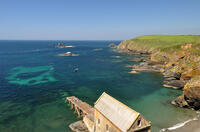
At the bottom of the slipway is a small beach of coarse grey sand which extends around the corner to a second area of beach at low tide. To the left of the lifeboat ramp is a large rock platform which extends out from the headland at low tide and contains a number of rockpools. The strong currents around Lizard Point make this an unsafe beach for swimming.
- Tide times
- Beach info
- Map
- Dogs: allowed all year
Circular walks visiting Polpeor Cove
-
3.8 miles/6.1 km - Moderate
Church Cove and Lizard Point

Church Cove and Lizard Point
3.8 miles/6.1 km - Moderate
A circular walk on The Lizard to the most southerly point from Church Cove, where the Lizard lifeboat is now launched to the old lifeboat station at Polpeor Cove.
-
4.4 miles/7.1 km - Moderate
The Lizard and Kynance Cove

The Lizard and Kynance Cove
4.4 miles/7.1 km - Moderate
A circular walk along the Victorian Excursion route from Lizard village to the most southerly point and along the coast path to Kynance Cove with spectacular views, wildflowers, and wildlife including the Cornish Chough.
-
7 miles/11.3 km - Moderate
Cadgwith Cove to The Lizard

Cadgwith Cove to The Lizard
7 miles/11.3 km - Moderate
A circular walk on The Lizard from the pretty fishing hamlet of Cadgwith Cove, past the Devil's Frying Pan, lifeboat station, restored Marconi wireless hut and the infamous lighthouse, to the most southerly point, returning via two ancient churches and the holy well dedicated to the Celtic Saint accused of being a werewolf.
Download the iWalk Cornwall app and use the QR scanner within the app to find out more about any of the walks above.

