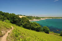
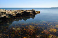
Porthallack beach

Porthallack is a small, southeast-facing sand and pebble beach near the mouth of the Helford River estuary and the coast path runs along the top of the beach. The proximity to the mouth of the estuary means that more seaweed seems to wash up here after storms than on the beaches further up the river. The beach is named Porthallack from the Cornish words for "willow trees" and "cove". The estuary is quite sheltered from the swell so there isn't much in the way of waves but currents in the river are quite strong, particularly at mid-tide. As the tide goes out, on the left side of the beach the pebbles increase in size to larger rocks.
Porthallack is near Porth Sawsen and about half its size. It can only be reached on foot (or by boat).
- Tide times
- Beach info
- Map
- Dogs: allowed all year
Circular walks visiting Porthallack beach
-
3.5 miles/5.6 km - Easy-moderate
Mawnan

Mawnan
3.5 miles/5.6 km - Easy-moderate
A circular walk through three of the wooded valleys to the sheltered coves at the mouth of the Helford River
-
5.8 miles/9.4 km - Easy-moderate
Rosemullion Head

Rosemullion Head
5.8 miles/9.4 km - Easy-moderate
A circular walk passing the National Trust's Glendurgan gardens and the equally spectacular submarine gardens of Rosemullion Head where fish dart amongst the brightly-coloured blooms.
Download the iWalk Cornwall app and use the QR scanner within the app to find out more about any of the walks above.

