St Loy's Cove

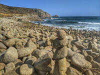
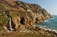
St Loy's Cove is entirely covered with large granite boulders at all states of the tide. When crossing the boulders, be aware that although most are steady, one or two do wobble. After storms, particularly in autumn, seaweed washes up onto the beach which can be quite smelly for a couple of weeks whilst it decays. A large iron tripod structure from a wrecked ship sits at the top of the shoreline.
The only public access to St Loy's Cove is from the coast path. In fact it forms part of the coast path.
- Tide times
- Beach info
- Map
- Dogs: allowed all year
Circular walks visiting St Loy's Cove
-
5.1 miles/8.2 km - Moderate-strenuous
Lamorna and St Loy

Lamorna and St Loy
5.1 miles/8.2 km - Moderate-strenuous
A circular walk visiting prehistoric stone circles, crosses and tombs and along the granite cliffs from Lamorna Cove to the sea-polished boulders of St Loy's Cove where sailors of a sinking vessel were able to climb to safety onto a large ship which had been wrecked there seven months before.
-
7.6 miles/12.3 km - Moderate-strenuous
St Buryan to Penberth Cove

St Buryan to Penberth Cove
7.6 miles/12.3 km - Moderate-strenuous
A circular walk along the granite cliffs and the valleys of St Loy's and Penberth Coves, where colourful gardens flourish in one of the mildest winter climates on the British mainland.
Download the iWalk Cornwall app and use the QR scanner within the app to find out more about any of the walks above.

