
Walks in Cornwall with thrift
Enjoy the walks by being guided by the app


-
1.9 miles/3 km - Easy
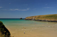
Park Head and Pentire Steps

Park Head and Pentire Steps
1.9 miles/3 km - Easy
A circular walk on Park Head, used as one of the filming locations in the Poldark BBC TV series and with spectacular views over Bedruthan Steps and the Trescore Islands. There is a nice display of thrift at Bedruthan Steps, between Pentire Steps and Carnewas.
-
2 miles/3.2 km - Easy
Trevose Head (short version)

Trevose Head (short version)
2 miles/3.2 km - Easy
A circular walk around the rugged coastline of Trevose Head via the iconic lighthouse and golden sandy beach at Mother Ivey's Bay, with spectacular wildflowers in spring and summer and thundering waves in winter that sometimes expose the shipwreck at Booby's Bay. There is a nice display of thrift on Dinas Head near the lighthouse.
-
2.5 miles/4 km - Easy
Botallack Head

Botallack Head
2.5 miles/4 km - Easy
A circular walk around Cornwall's most iconic mining remains, used for the filming of the BBC's Poldark series
-
3.5 miles/5.6 km - Easy
Bude to Northcott Mouth

Bude to Northcott Mouth
3.5 miles/5.6 km - Easy
A circular walk past the Sea Pool to Crooklets beach and along Maer cliff to the beach at Northcott Mouth, where the shipwreck of the SS Belem is exposed at low tide.
-
3.7 miles/6 km - Easy
Polzeath to St Enodoc Church

Polzeath to St Enodoc Church
3.7 miles/6 km - Easy
A circular walk along the coast from Polzeath past a number of small coves to the vast sandy beach at Daymer Bay, returning through the dunes past St Enodoc Church which was once so deeply buried in the sand that entrance for services was through the roof. There are some nice patches of thrift along the coast between Polzeath and Daymer Bay
-
2.2 miles/3.6 km - Easy-moderate
West Pentire and Polly Joke

West Pentire and Polly Joke
2.2 miles/3.6 km - Easy-moderate
A circular walk through the poppy fields of West Pentire to Polly Joke beach, returning over the headland to the pub that was a cowshed until the mid-20th Century.
-
2.5 miles/4 km - Easy-moderate
Stepper Point and the Doom Bar

Stepper Point and the Doom Bar
2.5 miles/4 km - Easy-moderate
A circular walk overlooking the infamous Doom Bar - from which the internationally popular beer is named - on which hundreds of vessels were wrecked when attempting to navigate into Padstow harbour and many still lie beneath the sands There are some nice patches of thrift along the coast from Trevone to Stepper Point.
-
3 miles/4.8 km - Easy-moderate
Tintagel Church to Trebarwith Strand

Tintagel Church to Trebarwith Strand
3 miles/4.8 km - Easy-moderate
A circular walk on quarrymens' trails along the cliffs of Tintagel past the Thunderhole blowhole to the long, sandy beach at Trebarwith Strand from Tintagel's mediaeval clifftop church with relics including the font that once stood in Tintagel Castle's chapel. There is a nice display of thrift around the coastal slate quarries and behind Hole Beach.
-
3.9 miles/6.2 km - Easy-moderate
Holywell to Polly Joke

Holywell to Polly Joke
3.9 miles/6.2 km - Easy-moderate
A circular walk from Holywell Bay on the dunes and Kelsey Head to the sandy beach of Polly Joke. There is a good display of thrift as you approach Porth Joke.
-
3.9 miles/6.3 km - Easy-moderate
Land's End

Land's End
3.9 miles/6.3 km - Easy-moderate
A circular walk on the rugged cliffs at the most westerly point of the British mainland with spectacular views and spectacular wildflowers. There is usually a nice display of thrift at Land's End.
-
4 miles/6.4 km - Easy-moderate
Watergate Bay to Newquay (via bus)

Watergate Bay to Newquay (via bus)
4 miles/6.4 km - Easy-moderate
A one-way coastal walk, made circular via an initial bus journey, from Watergate Bay along the coast path to Newquay, passing the sea caves at Whipsiderry beach, the Iron Age hillfort on Trevelgue head and the beaches of Porth, Lusty Glaze and Tolcarne.
-
4.9 miles/7.9 km - Easy-moderate
Constantine Bay to Porthcothan

Constantine Bay to Porthcothan
4.9 miles/7.9 km - Easy-moderate
A circular walk between Constantine Bay to Porthcothan via nature's swimming pool at Treyarnon beach and a spectacular series of islands, headlands and tiny coves named after wine and pepper smuggled there, and the rock where a customs officer was left by smugglers to drown. There is a lot of thrift between Treyarnon and Porthcothan; the wall behind Rowan Cove usually has an impressive display.
-
4.9 miles/7.9 km - Easy-moderate
Holywell to Crantock

Holywell to Crantock
4.9 miles/7.9 km - Easy-moderate
A circular walk from Holywell Bay past the remarkable sacred spring and along the coast to the sandy beaches of Porth Joke and Crantock, returning via the dunes of the Cubert Common nature conservation area. There is a good display of thrift as you approach Porth Joke.
-
5.8 miles/9.4 km - Easy-moderate
Rock to Polzeath

Rock to Polzeath
5.8 miles/9.4 km - Easy-moderate
A circular walk across the dunes and headland between Rock and Polzeath, returning via St Enodoc Church, where Sir John Betjeman is buried. There are some nice patches of thrift along the coast between Polzeath and Daymer Bay
-
6.1 miles/9.7 km - Easy-moderate
Trevose Head

Trevose Head
6.1 miles/9.7 km - Easy-moderate
A circular walk around the rugged coastline of Trevose Head via the iconic lighthouse and golden sandy bays of Constantine, Booby's, Mother Ivey's and Harlyn, with spectacular wildflowers in spring and summer. There is a nice display of thrift on Dinas Head near the lighthouse.
-
6.2 miles/10 km - Easy-moderate
Widemouth to Bude

Widemouth to Bude
6.2 miles/10 km - Easy-moderate
A circular walk from Widemouth Bay along the Coast Path though the Phillips Point nature reserve to The Storm Tower at Compass Point and then along the Bude Canal to Whalesborough, returning across the fields to Widemouth. There are some nice displays of thrift flowers on the cliff edges along the route including Compass Point overlooking the beach at Bude.
-
6.8 miles/10.9 km - Easy-moderate
Seven Bays (via bus)

Seven Bays (via bus)
6.8 miles/10.9 km - Easy-moderate
A one-way coastal walk, made circular via an initial bus journey, along the Seven Bays coast and around Trevose Head past the lighthouse. There is a lot of thrift between Treyarnon and Porthcothan; the wall behind Rowan Cove usually has an impressive display. Dinas Head near the lighthouse also has a nice display.
-
2.9 miles/4.7 km - Moderate
Port Quin to Lundy Bay

Port Quin to Lundy Bay
2.9 miles/4.7 km - Moderate
A circular walk from the fishing village of Port Quin to the golden sandy beaches of Epphaven Cove and Lundy Bay with spectacular coastal scenery, via the cliff-edge folly on Doyden Point built as a gambling den.
-
3.3 miles/5.3 km - Moderate
Boscastle Headlands

Boscastle Headlands
3.3 miles/5.3 km - Moderate
A circular walk from Boscastle to Pentargon waterfall and Willapark coastguard lookout with magnificent views of the village and harbour from the headlands where the village women once gathered dressed in red to fool a French ship into fleeing from British army redcoats.
-
3.5 miles/5.7 km - Moderate
West Pentire to Crantock Beach

West Pentire to Crantock Beach
3.5 miles/5.7 km - Moderate
A circular walk on the northernmost end of one of Cornwall's largest areas of sand dunes that stretch from Crantock to Perranporth, under which one mediaeval chapel was found and another is said to still be lost.
-
3.7 miles/6 km - Moderate
St Just to Cape Cornwall

St Just to Cape Cornwall
3.7 miles/6 km - Moderate
A circular walk from St Just to the rugged coast of England's only Cape topped by a monument fashioned from a mine chimney, passing mediaeval and prehistoric remains. There is a nice display of thrift on the end of Cape Cornwall and on some of the cliff edges along the route.
-
3.8 miles/6.1 km - Moderate
Porth Nanven to Nanquidno

Porth Nanven to Nanquidno
3.8 miles/6.1 km - Moderate
A circular walk from the Cot Valley past the beaches of Nanquidno and Porth Nanven where granite boulders polished over millions of years by prehistoric oceans and then buried by the soil are being exposed once again by the sea. There is a nice display of thrift on some of the cliff edges along the route.
-
3.9 miles/6.3 km - Moderate
Perranuthnoe to Prussia Cove
")
Perranuthnoe to Prussia Cove
3.9 miles/6.3 km - Moderate
A circular walk along Mount's Bay from the large sandy beach at Perranuthnoe to the smugglers' coves at Prussia Cove, returning across the fields with views over St Michael's Mount. There is a nice display of thrift around Pixies (aka Piskies) Cove.
-
4.1 miles/6.5km - Moderate
Trewarmett to Trebarwith Strand

Trewarmett to Trebarwith Strand
4.1 miles/6.5km - Moderate
A circular walk down Trebarwith Valley to Trebarwith Strand then along the cliffs above the beach, with magnificent views of the bay between Dennis Point and Penhallic Point and the pinnacles of the coastal slate quarries now colonised by birds and wildflowers.
-
4.2 miles/6.7 km - Moderate
The Rumps to Polzeath around Pentire Point

The Rumps to Polzeath around Pentire Point
4.2 miles/6.7 km - Moderate
A circular walk across the Iron Age hillfort on the twin headlands of The Rumps and around Pentire Point, with panoramic views of the Camel Estuary and the offshore islands, to the sandy beach at Polzeath. There is some nice thrift between The Rumps and Pentire Point
-
4.3 miles/7 km - Moderate
St Ives

St Ives
4.3 miles/7 km - Moderate
A circular walk at St Ives along the granite coastline and white sandy beaches which have inspired so many artists, through some of the most famous parts of the town including the harbour, The Island and The Tate, and via the church and holy well of the Celtic girl Ia who, according to legend, was the first to settle here.
-
4.4 miles/7.1 km - Moderate
Porthallow to Gillan

Porthallow to Gillan
4.4 miles/7.1 km - Moderate
A circular walk up Gillan Creek from Porthallow via Nare Point where, during World War II, an elaborate decoy for Falmouth Harbour was created by Ealing Film Studios with fake railways, houses and explosive special effects.
-
4.5 miles/7.3 km - Moderate
Bedruthan Steps

Bedruthan Steps
4.5 miles/7.3 km - Moderate
A circular walk with spectacular views of the rock stacks at Bedruthan Steps, about which the myth of a giant's stepping stones was concocted for the amusement of Victorian tourists flocking to Padstow and Newquay on the new railway. There is a nice display of thrift at Bedruthan Steps, between Pentire Steps and Carnewas.
-
4.7 miles/7.5 km - Moderate
Perranporth to St Agnes (via bus)

Perranporth to St Agnes (via bus)
4.7 miles/7.5 km - Moderate
A one-way coastal walk, made circular via an initial bus journey, along the ore-bearing cliffs between Perranporth and St Agnes passing the remains of Nobel's dynamite works, Britain's best preserved spitfire base and the Blue Hills of Trevellas Coombe where tin is still processed on a small scale using traditional methods.
-
4.7 miles/7.5 km - Moderate
Porthtowan to Chapel Porth

Porthtowan to Chapel Porth
4.7 miles/7.5 km - Moderate
A circular walk from Porthtowan, along the coast, valleys and woodland, passing engine houses and other relics of Cornish copper mining.
-
5.0 miles/8.1 km - Moderate
Hell's Mouth to Godrevy

Hell's Mouth to Godrevy
5.0 miles/8.1 km - Moderate
A circular walk following the coast from Hell's Mouth past Godrevy lighthouse to the sandy beaches of St Ives Bay, returning via a pilgrimage route along the Red River Valley.
-
5 miles/8 km - Moderate
Trebarwith Strand to Tintagel Castle

Trebarwith Strand to Tintagel Castle
5 miles/8 km - Moderate
A walk on the tracks trodden by the donkeys laden with slate from the coastal quarries of Trebarwith to Tintagel Haven where the slate was loaded onto ships and Tintagel Castle's island, inhabited during the mediaeval period, the Celtic times of King Arthur, and before this by the Romans. There is a nice display of thrift around the coastal slate quarries and behind Hole Beach.
-
5.1 miles/8.2 km - Moderate
Predannack to Kynance Cove

Predannack to Kynance Cove
5.1 miles/8.2 km - Moderate
A circular walk through the Lizard National Nature Reserve from Predannack to Kynance Cove along the rugged Serpentine cliffs where the "great silver ship" was wrecked in 1616 and more than 700 Spanish silver coins have so far been found.
-
5.2 miles/8.3 km - Moderate
Sennen Cove to Nanquidno

Sennen Cove to Nanquidno
5.2 miles/8.3 km - Moderate
A circular walk alongside the pristine beaches of Whitesand Bay, where shoals of mullet are still caught off the beach using the traditional seine nets in the way they have for hundreds of years. There is a nice display of thrift as you approach Sennen Cove at the end of the walk.
-
5.3 miles/8.5 km - Moderate
Gunwalloe Coves

Gunwalloe Coves
5.3 miles/8.5 km - Moderate
A circular walk from the Loe Bar to Dollar Cove passing the wrecks of treasure ships whose cargo still washes ashore, returning via the Halzephron Inn which still has a trapdoor leading to an underground network of tunnels used by smugglers. There are some nice patches of thrift along the footpath to fishing cove.
-
5.4 miles/8.6 km - Moderate
Cape Cornwall to Levant

Cape Cornwall to Levant
5.4 miles/8.6 km - Moderate
A circular walk from England's only Cape, via the engine houses of Kenidjack Valley and perched on rock ledges at Botallack Head, to Levant Mine which had over 60 miles of tunnels beneath the Atlantic and now has a working restored beam engine.
-
5.7 miles/9.1 km - Moderate
Perranporth to Trevellas

Perranporth to Trevellas
5.7 miles/9.1 km - Moderate
A circular walk past the remains of Alfred Nobel's dynamite works to the red-and-yellow ore-rich cliffs above the wreck of the treasure ship Hanover, returning, via the spitfire base, along Perran Coombe where a 2-mile leat once carried water to power a massive waterwheel in a chamber within the cliffs.
-
5.8 miles/9.3 km - Moderate
Newquay

Newquay
5.8 miles/9.3 km - Moderate
A circular walk around the UK's surf capital which was transformed from a tiny fishing village with a few thatched cottages when, in order to export ore from the harbour, a horse-drawn tramway was built across Cornwall which later became part of the Great Western Railway.
-
5.9 miles/9.5 km - Moderate
Trewarmett to Tregardock

Trewarmett to Tregardock
5.9 miles/9.5 km - Moderate
A circular walk to the remote sandy beach at Tregardock, returning along the coast path with panoramic views of Port Isaac Bay, through the wildflowers of Treligga Downs and via Backways Cove.
-
6 miles/9.7 km - Moderate
Sennen Cove, Land's End and Nanjizal

Sennen Cove, Land's End and Nanjizal
6 miles/9.7 km - Moderate
A circular walk from the white sandy beach at Sennen Cove along the towering granite cliffs via Land's End to the song of the sea cave at Nanjizal. The best way to see Land's End. There is usually a nice display of thrift at Land's End.
-
6.2 miles/10 km - Moderate
Bedruthan Steps to Porthcothan

Bedruthan Steps to Porthcothan
6.2 miles/10 km - Moderate
A circular walk featuring some of the most spectacular scenery of the North Cornish coast including the rock stacks of Bedruthan Steps, the azure lagoon of the Trescore Islands and the sheltered golden sandy beach at Porthcothan. There is a nice display of thrift at Bedruthan Steps, between Pentire Steps and Carnewas.
-
6.2 miles/10 km - Moderate
Chapel Porth to Trevaunance Cove

Chapel Porth to Trevaunance Cove
6.2 miles/10 km - Moderate
A circular walk along the coast between the golden sandy beaches of Chapel Porth and Trevaunance Cove at St Agnes via the iconic engine houses of Wheal Coates, perched above the breakers.
-
6.2 miles/10 km - Moderate
Mullion to Predannack

Mullion to Predannack
6.2 miles/10 km - Moderate
A circular walk passing the sandy beach at Polurrian Cove, the storm-beaten Victorian harbour at Mullion Cove, and along the cliffs of the National Nature Reserve overlooking Mullion Island, with vibrant wildflowers in spring and summer.
-
6.9 miles/11.2 km - Moderate
Holywell Bay to Newquay (via bus)

Holywell Bay to Newquay (via bus)
6.9 miles/11.2 km - Moderate
A one-way coastal walk, made circular via an initial bus journey, from Holywell Bay along the coast and Gannel estuary to Newquay, passing the beaches of Porth Joke and Crantock and the headland of West Pentire where there is a spectacular display of red-and-gold wildflowers in June. There is a good display of thrift as you approach Porth Joke.
-
7.4 miles/11.9 km - Moderate
Holywell to St Piran's Oratory

Holywell to St Piran's Oratory
7.4 miles/11.9 km - Moderate
A circular walk from Holywell Bay along the rugged coastline to Perran Beach and across the dunes to the mediaeval relics of St Piran's Oratory, Church and Cross, returning via the Penhale Sands nature reserve which is carpeted in cowslips during spring. There is some nice thrift along the coast between Holywell Bay and Perranporth. Ligger Point often has a nice display.
-
7.4 miles/11.8 km - Moderate
St Just to Nanquidno

St Just to Nanquidno
7.4 miles/11.8 km - Moderate
A circular walk from St Just to Cape Cornwall and the Cot Valley, where an ancient beach has been eroded from the cliffs at Porth Nanven, releasing granite boulders resembling Dinosaur eggs. There is a nice display of thrift on the end of Cape Cornwall and on some of the cliff edges along the route.
-
7.4 miles/12.1 km - Moderate
Trevone to Padstow

Trevone to Padstow
7.4 miles/12.1 km - Moderate
A circular walk to Padstow from Trevone beach, which tracks the route taken by sailing ships along the rugged Atlantic coast to the daymark at Stepper Point, past the infamous Doom Bar and the sandbanks of Hawker's, Harbour and St George's coves before finally reaching safe harbour in Padstow. There are some nice patches of thrift along the coast from Trevone to Stepper Point.
-
2.2 miles/3.5 km - Moderate-strenuous
Trebarwith Strand to Backways Cove

Trebarwith Strand to Backways Cove
2.2 miles/3.5 km - Moderate-strenuous
A short circular walk from the long, sandy beach of Trebarwith Strand to the rugged rocky cove at Backways in which sea foam tornadoes form in windy weather, and returning over the massive headland of Dennis Point with panoramic views of Port Isaac Bay.
-
2.3 miles/3.7 km - Moderate-strenuous
Morwenstow and Tidna Valley

Morwenstow and Tidna Valley
2.3 miles/3.7 km - Moderate-strenuous
A short circular walk at Morwenstow to the cliff edge hut built from driftwood in which Reverend Hawker smoked opium and composed poetry, returning along the river valley to the ancient Bush Inn where medieval monks would rest the night before continuing their pilgrimage.
-
3.8 miles/6.2 km - Moderate-strenuous
Morwenstow to Stanbury Mouth

Morwenstow to Stanbury Mouth
3.8 miles/6.2 km - Moderate-strenuous
A circular walk from Morwenstow along the shipwreck coast to Stanbury Mouth where only nature's by-the-wind sailors now run aground
-
4 miles/6.4 km - Moderate-strenuous
Trebarwith Valley to Backways Cove

Trebarwith Valley to Backways Cove
4 miles/6.4 km - Moderate-strenuous
A circular walk in Trebarwith Valley to beaches and the coastal slate quarries of Backways Cove and Trebarwith Strand, and Dennis Point, overlooking the bay and point opposite where the ships moored to be loaded with roofing slates which were also brought down the valley on a road covered with beach sand to stop the horses being flattened by runaway carts.
-
4.3 miles/6.9 km - Moderate-strenuous
Crackington Haven to The Strangles

Crackington Haven to The Strangles
4.3 miles/6.9 km - Moderate-strenuous
A circular walk from Crackington Haven, with panoramic views of the Shipwreck Coast, to the long, sandy Strangles beach, returning through bluebell woodland along the Ludon river valley.
-
5.4 miles/8.7 km - Moderate-strenuous
Boscastle to Buckator

Boscastle to Buckator
5.4 miles/8.7 km - Moderate-strenuous
A circular walk along the coastline from Boscastle via the Pentargon waterfall and the rugged cliffs at Buckator, returning along the Valency valley.
-
5.4 miles/8.6 km - Moderate-strenuous
Duckpool to Woodford

Duckpool to Woodford
5.4 miles/8.6 km - Moderate-strenuous
A circular walk in Morwenstow parish along towering cliffs and through broadleaf woods where a hamlet has been preserved in a joint project between the Landmark Trust and National Trust
-
6 miles/9.7 km - Moderate-strenuous
Port Gaverne to Barretts Zawn

Port Gaverne to Barretts Zawn
6 miles/9.7 km - Moderate-strenuous
A circular walk from Port Gaverne around Port Isaac Bay to Barretts Zawn, where a tunnel leads to the beach, through which donkeys used to haul slate.
-
6.8 miles/11.0 km - Moderate-strenuous
Porthcothan, Bedruthan Steps and Watergate Bay (via bus)
Porthcothan, Bedruthan Steps and Watergate Bay (via bus)
6.8 miles/11.0 km - Moderate-strenuous
A (bus-assisted) one-way walk along the coast with spectacular wildflowers and one of Cornwall's most photographed views over the volcanic rock stacks of Bedruthan Steps, which Victorians liked to think of as a giant's stepping stones. There is a nice display of thrift at Bedruthan Steps, between Pentire Steps and Carnewas.
-
6.8 miles/10.9 km - Moderate-strenuous
Porthleven to Rinsey Head

Porthleven to Rinsey Head
6.8 miles/10.9 km - Moderate-strenuous
A circular walk from Porthleven to the cliff-edge engine houses of Rinsey Head and Trewavas where the under-sea mine, set out with tables and food for the annual Tribute dinner, is said to have been breached by the sea just minutes before all the miners were due underground.
-
9.9 miles/15.9 km - Moderate-strenuous
Port Isaac to Polzeath (via bus)

Port Isaac to Polzeath (via bus)
9.9 miles/15.9 km - Moderate-strenuous
A one-way coastal walk, made circular via an initial bus journey, from Port Isaac to Polzeath along the Rollercoaster Path to Port Quin, the golden beaches of Lundy Bay via the Iron Age hillfort on the twin headland of The Rumps. There is some nice thrift between The Rumps and Pentire Point
-
7 miles/11.2 km - Strenuous
Crackington Haven to Boscastle (via bus)

Crackington Haven to Boscastle (via bus)
7 miles/11.2 km - Strenuous
A one-way coastal walk, made circular via an initial bus journey, along the Shipwreck Coast from Crackington Haven to Boscastle passing the highest cliff in Cornwall and the long, sandy beach at The Strangles.
-
7.3 miles/11.7 km - Strenuous
Portreath to Wheal Tye

Portreath to Wheal Tye
7.3 miles/11.7 km - Strenuous
A circular walk along the rugged coast from Portreath towards Porthtowan passing small coves and remnants of the clifftop mines beside the old RAF base, and returning via the horse-drawn tramway that brought fortune to Portreath harbour, where its "lighthouse" and "monkey house" remain from the shipping activity. There are nice displays of thrift along the coast from Gooden Heane Point.
-
9.7 miles/15.6 km - Strenuous
Port Isaac to Tintagel

Port Isaac to Tintagel
9.7 miles/15.6 km - Strenuous
A one-way walk from Port Isaac to Tintagel along towering cliffs, past the long, sandy beaches of Tregardock and Trebarwith, the slate pinnacles of the coastal quarries and via the mediaeval cliff-top church to the castle of Arthurian legend. There is a nice display of thrift around the coastal slate quarries and behind Hole Beach.


")


Download the iWalk Cornwall app and use the QR scanner within the app to find out more about any of the walks above.
